By: Ken Tape, Research Associate Professor at the University of Alaska Fairbanks
Beavers are ecosystem engineers that alter hydrology and impact many aspects of stream and surrounding ecosystems. Because herbivores, including moose and snowshoe hares, have moved from the boreal forest into increasing Arctic tundra shrub habitat during the last century, we thought it would be interesting to explore whether beavers would soon be following them from the forest to the tundra. We struck on the notion that the formation or disappearance of beaver ponds could be detected through time using satellite imagery, thus possibly allowing us to map beaver encroachment or emigration in tundra regions. We assembled a team of researchers with experience detecting change in the tundra environment, particularly with Arctic lakes, which related to our beaver question. Ken Tape, Benjamin Jones, and Christopher Arp at the University of Alaska Fairbanks developed the idea and approach; Ingmar Nitze and Guido Grosse at the Alfred Wegener Institute in Germany provided insight and remote sensing support. The project was funded in part by a National Science Foundation (NSF) Alaska Established Program to Stimulate Competitive Research (EPSCoR) grant, the State of Alaska, the European Research Coucil, a Hemholz Association Initiative and Networking Fund grant, the European Space Agency GlobPermafrost, and the University of Alaska Fairbanks Office of the Vice Chancellor for Research.
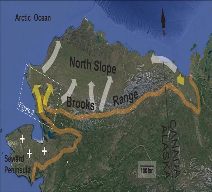
We developed an approach that used Landsat wetting and drying temporal trends between 1999 and 2014 to locate potential sites of beaver pond formation (wetting) or disappearance (drying). Wetting locations were further constrained using a suite of geographic filters to reduce the number of wetting locations that were not due to beaver pond construction but were instead due to other natural wetting processes. We then used high-resolution satellite imagery to confirm whether the wetting or drying locations were due to beavers or other causes. This powerful technique allowed us to detect beaver pond formation and drying across an 18,000+ km2 predominantly tundra area in the western Brooks Range of Alaska. We eventually identified 56 new beaver ponds using this method, which indicated that beavers are moving from treeline into Arctic tundra regions. In Figure 1, the orange line approximates treeline, which was historically considered to be the range limit of beavers (Bockstoce, 2009; McCulloch and Hopkins, 1966). Yellow arrows denote known beaver colonization routes since 1999, including an observation of a new dam on the Babbage River in Canada (Jung et al. 2017), and evidence of many new dams and ponds in the white box covering the western Brooks Range. The white arrows speculate future colonization routes, and plus signs indicate observations of beaver ponds beyond the treeline on the Seward Peninsula.

It remains unclear whether this colonization of the tundra by beavers is the result of increasing shrub habitat, as well as increasing unfrozen water in winter, or whether it is a population rebound from over-trapping a century ago, and they are reoccupying their former range. We are working with the National Park Service to examine archaeological and anthropological records to explore this issue.
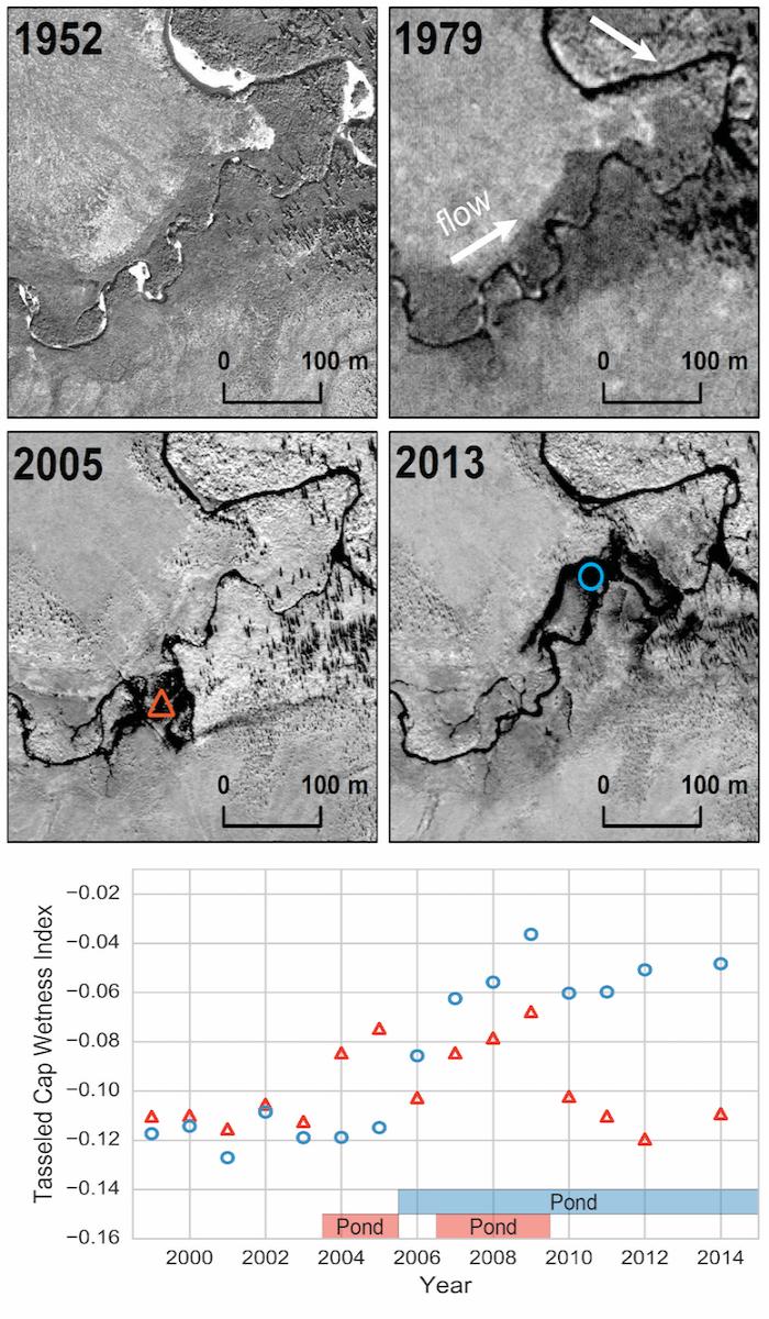
The more pressing question to us is, how will beavers impact the tundra permafrost environment, and what will be unique compared to their impacts in temperate ecosystems? From the review of time series imagery, it is striking to our team how immediately and dramatically the changes occur when beavers arrive. The time series of high-resolution satellite imagery show that streams turn into a series of interconnected channels and ponds resembling a wetland, and lateral permafrost thaw is evident around the newly-inundated locations (see Figure 2). Our understanding of physical impacts resulting from inundation and deeper water (ponding) suggests that the observed lateral permafrost thaw is accompanied by permafrost thaw underneath the new pond because water transfers heat more efficiently than the preexisting tundra vegetation. Deeper water in winter also translates to later ice formation and warmer water, which exacerbates underlying permafrost thaw. Warmer water also leaks downstream, creating more unfrozen water in winter. In this way, the footprint of thermal (and likely biological) impact of beavers could be considered local to the area surrounding engineered ponds, but with a tail of uncertain length where warmer water extends downstream.

The impacts of beavers in the Arctic tundra had not been studied prior to our exploratory results. Physical impacts, such as permafrost thaw or warmer water, are more reliable because this process has been studied in the Arctic for over a half-century. Our predictions of biological impacts, however, are much more uncertain due to their complexity and lack of study. We think that warmer water in winter and more varied aquatic habitat created by beavers will create oases in the Arctic, replete with shrubbier vegetation, more unfrozen water in winter, enhanced aquatic productivity and biodiversity, and likely new species, including fish. Because beavers impact so many aspects of terrestrial and aquatic ecosystems, and because these impacts can vary from one beaver pond to the next, it will be challenging to quantify and summarize their current and future impacts on the Arctic tundra biome.
Our current efforts are to map changes in beaver pond location in the Arctic over the last 20 years, as well as to substantiate our understanding of beaver impacts with a multitude of field measurements. The best analog for beavers and their impacts in the Arctic tundra might be wildfire. Both of these ecological disturbances seem to have been rare or absent in the tundra prior to their recent appearance, and their arrival appears like a hammer to the system in comparison with some of the incremental changes that we are more familiar with, such as permafrost thaw or shrub expansion. Further study is needed to better understand the role of beaver colonization in tundra shrub habitat, which constitutes a new and dramatic disturbance that could accelerate the changes already underway in the Arctic.
 Ken Tape is a Research Associate Professor at the University of Alaska Fairbanks with broad interests in the Arctic natural sciences. His research describes the impacts of climate warming during the 20th century on various components of the Arctic ecosystems, including the vegetation, permafrost, hydrology, and wildlife. He enjoys boating, skiing, snowmachining, dog-mushing, photographing, studying, and writing about the major river systems in northern Alaska.
