By: Antoni Lewkowicz, Department of Geography, Environment, and Geomatics at the University of Ottawa
Thaw of permafrost containing high concentrations of ground ice can dramatically impact Arctic environments. Several different types of thermokarst—processes and landforms associated with melt of ice in the ground—can result. Retrogressive thaw slumps constitute the most important type of thermokarst landform on sloping terrain.
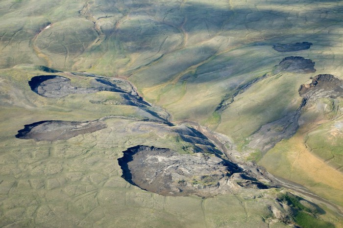
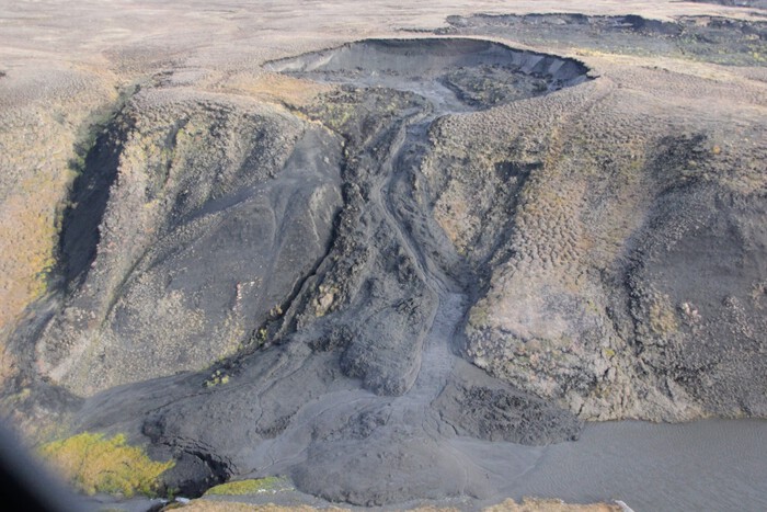
A retrogressive thaw slump (RTS) is a horseshoe-shaped landslide, with a steep headscarp (erosional face of the landslide), composed of unfrozen soil overlying ice-rich permafrost (See Figures 1 and 2). Once exposed, the melting ice undermines the active layer which collapses and temporarily covers it, and the two then mix together and exit the slump downslope as a mudflow. The latter can discharge into a river, a lake, or the ocean, or stabilize on a lower-angled part of the slope, covering the tundra vegetation.
Unlike many other landslides, RTS are not just active the year that they are triggered but may reactivate every summer for up to 50 years. During this extended period, RTS alter the landscape, affect water quality and aquatic ecosystems, and liberate frozen organic carbon for subsequent decomposition, thereby contributing to the permafrost carbon feedback.
The analyses that Robert Way (Assistant Professor at Queen's University, Canada) and I undertook were based on the Google Earth Engine Timelapse dataset. This is a series of annual cloud-free satellite images arranged as a zoomable timelapse video running from 1984 to 2016. A retrogressing headwall of an active RTS appears visually as movement in the video, and by stepping through the images one frame at a time, the year that an RTS first appears and the year it stabilizes can be recorded. This is a time-consuming process compared to automated image analysis methods (e.g. Nitze et al., 2018) but the resultant database has a high level of accuracy (-5% to +10%).
Prior to our work, Inuvialuit residents of the hamlet of Sachs Harbour on Banks Island in the western Canadian Arctic had reported seeing more slumps, which were starting to affect travel for traditional hunting and fishing activities (Riedlinger and Berkes 2001). Several publications had confirmed this increase for selected parts of the island (Segal et al. 2016, Rudy et al. 2017, Kokelj et al. 2017). It was inferred that these changes were due to climate warming or enhanced precipitation, but their timing, continuity, and links to climate remained to be established.
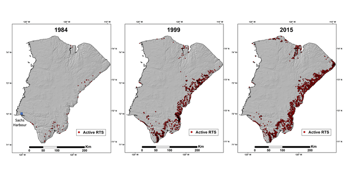
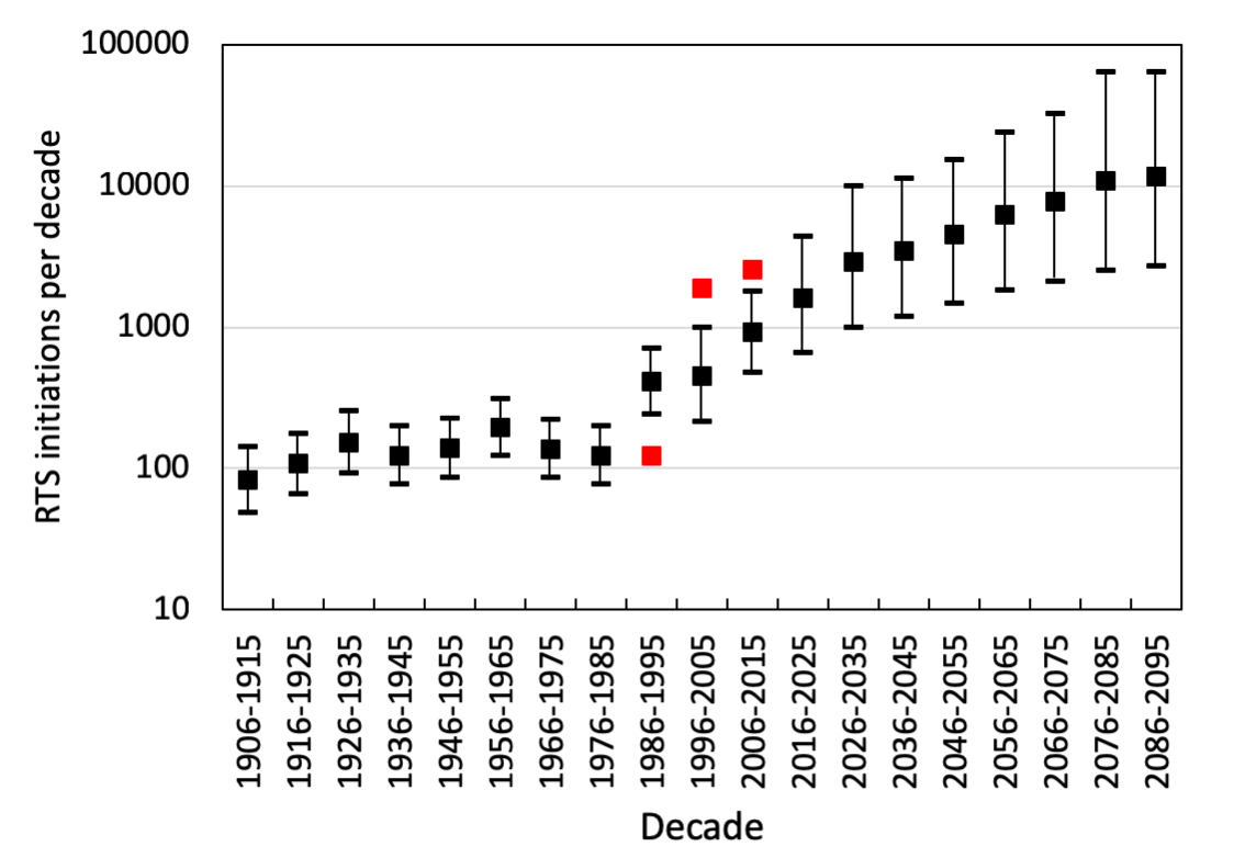
Our results showed a 60-fold increase in the number of RTS active on Banks Island (area 70,000 km2). Between 1984 and 2015, numbers grew from about 60 to more than 4,000 (See Figure 3). Eighty-five percent of this tremendous increase occurred following four particularly warm summers: 1998, 2010, 2011, and 2012. We found that half of the RTS remained active for at least 30 years so that all of these warm summers are continuing to have effects. We also documented a spread of thaw slumps towards the north of the island in 2010-2012 compared to 1998, which coincided with increased summer warmth, possibly linked to a decrease in sea ice concentrations in M'Clure Strait.
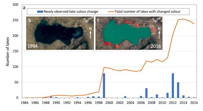
We observed obvious physical impacts of the increase in RTS on aquatic environments. More than 250 lakes changed color from dark blue in the imagery (i.e. transparent) to turquoise or beige (i.e., turbid), coincident with slump development on their shorelines or in contributing watersheds (See Figure 4). Sediment accumulation was also widespread in many river valleys (e.g., Figure 2). The impacts of these changes are not yet known, but studies elsewhere have shown the effect of RTS on lake and river chemistry (Kokelj et al. 2013), including the potential for mercury release (St Pierre et al. 2018), as well as outputs of organic carbon (Ramage et al. 2018).
Given the strong link between RTS initiation and summer warmth, we were able to hindcast rates for the twentieth century and forecast rates for the future. This empirical modelling gave an average initiation rate of 132 per decade for 1906–1985, which increased to 915 per decade for 2006–2015 (observed rate 2542) and to more than 10,000 per decade in the last quarter of the twenty-first century under the RCP4.5 moderate warming scenario (See Figure 5).
Our results add to growing evidence that areas of cold permafrost can be vulnerable to rising summer temperatures providing there are high concentrations of ground ice immediately beneath the active layer (e.g. Fraser et al. 2018). Fortunately, this is not the case for the entire Arctic, as indicated by the relatively small numbers of RTS detected between 1999–2014 on transects in eastern Canada, Alaska, and Siberia (Nitze et al. 2018). But unfortunately, our ongoing work on RTS development in other parts of the western Arctic where the permafrost is ice-rich clearly shows that Banks Island is not unique.
The landscape of Banks Island has changed significantly, starting two decades ago in the warm summer of 1998. The projected RTS initiation rates for 2076–2085, more than 100 times those estimated for the start of the twentieth century, will further exacerbate these unprecedented impacts on the tundra environment of Banks Island and on the Inuvialuit who live there.
For more information about this research, please see Extremes of Summer Climate Trigger Thousands of Thermokarst Landslides in a High Arctic Environment, and the Retrogressive Thaw Slump (RTS) Development - Canadian Arctic.
[video:]
About the Author
 Antoni Lewkowicz is Professor in the Department of Geography, Environment, and Geomatics at the University of Ottawa, Canada. His research concerns the impact of climate change on permafrost distribution and characteristics, including slope processes. He is a former president of the International Permafrost Association (2012-2016) and is the first president of the recently formed Canadian Permafrost Association.
References
Fraser, R.H., Kokelj, S.V., Lantz, T.C., McFarlane-Winchester, M., Olthof, I., Lacelle, D. 2018. Climate sensitivity of high Arctic permafrost terrain demonstrated by widespread ice-wedge thermokarst on Banks Island. Remote Sensing 10: 954.
Kokelj, S.V., Lacelle, D., Lantz, T.C., Tunnicliffe, J., Malone, L., Clark, I.D., Chin, K.S. 2013. Thawing of massive ground ice in mega slumps drives increases in stream sediment and solute flux across a range of watershed scales. Journal of Geophysical Research – Earth Surface 118: 681–692.
Kokelj, S.V., Lantz, T.C., Tunnicliffe, J., Segal, R., Lacelle, D. 2017. Climate-driven thaw of permafrost preserved glacial landscapes, northwestern Canada. Geology 45: 371–374.
Nitze, I., Grosse, G., Jones, B.M., Romanovsky, V.E., Boike, J. 2018. Remote sensing quantifies widespread abundance of permafrost region disturbances across the Arctic and Subarctic. Nature Communications 9: 5423.
Ramage, J.L., Irrgang, A.M., Morgenstern, A., Lantuit, H. 2018. Increasing coastal slump activity impacts the release of sediment and organic carbon into the Arctic Ocean. Biogeosciences 15: 1483–1495.
Riedlinger, D., Berkes, F. 2001. Contributions of traditional knowledge to understanding climate change in the Canadian Arctic. Polar Record 37: 315–328.
Rudy, A.C.A., Lamoureux, S.F., Kokelj, S.V., Smith, I.R., England, J.H. 2017. Accelerating thermokarst transforms ice-cored terrain triggering a downstream cascade to the ocean. Geophysical Research Letters 44: 11,080–11,087.
Segal, R.A., Lantz, T.C., Kokelj, S.V. 2016. Acceleration of thaw slump activity in glaciated landscapes of the Western Canadian Arctic. Environmental Research Letters 11 (3): 034025.
St Pierre, K.A., Zolkos, S., Shakil, S., Tank, S.E., St Louis, V.L., Kokelj, S.V. 2018. Unprecedented increases in total and methyl mercury concentrations downstream of retrogressive thaw slumps in the western Canadian Arctic. Environmental Science and Technology 52: 14099–14109.
