By: Thomas A. Douglas, US Army Engineer Research and Development Center's Cold Regions Research and Engineering Laboratory, Alaska
The US Army Cold Regions Research and Engineering Laboratory (CRREL) and collaborators have been working for more than 60 years at their Permafrost Tunnel (Tunnel) site situated in Fox, Alaska, near the valley floor of Goldstream Creek, 16 miles north of Fairbanks. Permafrost—earth material like rock, soil, ice, or organic matter that remains frozen for multiple years—underlies 21 million square kilometers of the Northern Hemisphere. Early tunnel studies focused on permafrost engineering and geotechnical properties because the Alaska Highway, expanded roads and airfields across Alaska, and the Trans-Alaska Pipeline provided needs for unique engineering solutions. Over subsequent years, interest in permafrost geophysics, ecology, biogeochemistry, and paleoclimate studies have increased along with new engineering needs. Most of the projects at the Permafrost Tunnel site have occurred inside the underground tunnels themselves. A recent tripling of the tunnel subsurface area provides access to additional massive ice features, ancient soils and vegetation, and bones from the mammoths and steppe bison that roamed interior Alaska when it was a colder place 20,000 years ago.
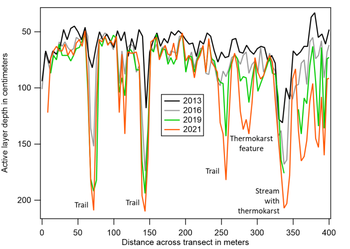
However, the land above the Permafrost Tunnel facility provides access to modern permafrost dynamics and the number of above-ground studies is increasing. Climate warming across interior Alaska over the past ten years has dramatically increased top-down thaw of permafrost, as well as the initiation and growth of thermokarst features (e.g., pits, scarps, and other subsidence features formed when ice-rich permafrost degrades and the ground collapses). Many of these features have formed over the past decade in the boreal forest above the Permafrost Tunnel and at many nearby study sites. Repeat end-of-summer thaw depths (i.e., active layer thickness) have been made since 2013 by pushing a rod into the ground and noting the "depth to refusal". Over the nine-year measurement record, the seasonal thaw depth—and thus the depth to the top of near-surface permafrost—has increased by at least 50% in most places (Figure 1). In some areas, particularly near clearings, trail crossings, and other disturbed sites, it has more than doubled. Extrapolated over hundreds of thousands of square kilometers across interior Alaska, this is a lot of thawed ground. However, there is no readily apparent change in the landscape from this type of thaw.
The most dramatic manifestation of permafrost degradation in the area is the development of thermokarst features where ice-rich permafrost thaws—pits, scarps, holes, tunnels, and slumps—can grow by as much as five meters (15 feet) over the course of one summer. These are forming unpredictably across the landscape and continued climate warming will produce new features and promote expansion of existing ones. A dramatic example of one of these features is shown in Figure 2. In late May 2020, a moose carcass was found at the base of a thermokarst feature above the Permafrost Tunnel. There were no signs of predation and the moose appeared a few years old and healthy. A hypothesis about this finding is that the moose got stuck in the tangle of vegetation and deep snow, could not get out of the pit, and died.

Remote sensing measurements using drone and satellite platforms, high resolution ground surveys, vegetation measurements, borehole sampling, and temperature monitoring efforts have been expanded across the Permafrost Tunnel site to identify how, where, and how rapidly these features form. Repeat photography from ground and airborne platforms provide an assessment of surface dynamics and vegetation changes. We are also using high resolution repeat LiDAR analyses to measure ground surface changes within centimeters. Another promising tool is the use of synthetic aperture radar from airborne and satellite platforms. These projects include collaborations with the University of Alaska Fairbanks, California State University Northridge, University of New Hampshire, University of Wyoming, University of Colorado Boulder, Colorado State University, Florida Atlantic University, Alaska Ecoscience, NASA, the US Naval Academy, West Point Military Academy, the National Geospatial Agency, and others. All of the measurements we have made with these tools show the landscape is changing rapidly and likely, irreversibly.
Expanded development of thermokarst features will continue to affect hydrology, forest and habitat ecology, and the carbon cycle. Permafrost thaw and thermokarst will increasingly challenge infrastructure siting, design, and maintenance efforts. Over the next few years, with funding from the US Army, the Department of Defense's Environmental Science and Technology Certification Program, NASA, and efforts of our collaborative team, we will apply geospatial statistical analyses to develop risk maps for landscape change. Top-down and lateral thaw feature development will continue to be tracked. Biogeochemical processes that are initiated when soils thaw will be investigated for their role in liberating trace metals and affecting the carbon cycle. Ground source heat pump technology will be tested for its efficacy in heating buildings and cooling permafrost. A variety of energy, water/wastewater, and structural investigations will be undertaken at the site. We envision a new era in research and engineering activity at the Permafrost Tunnel site and welcome collaborators to work with us to address these emerging science and engineering topics.
About the Author
 Thomas A. Douglas, PhD, research chemist, is a senior scientist for the US Army Engineer Research and Development Center's Cold Regions Research and Engineering Laboratory in Alaska. He has worked at CRREL since 2001 after receiving a doctoral degree in Earth Sciences from Dartmouth College. His research is focused on the environmental characterization of permafrost, snow, and ice to support infrastructure development and to understand the response of Arctic and subarctic terrains to climate warming. He has participated in multiple 500–1,000 mile wintertime traverses across the Alaskan Arctic and has worked at remote field sites in Alaska, Canada, and Greenland. Douglas is an author or co-author of more than 100 scientific papers and book chapters. Contact: Thomas.A.Douglas [at] usace.army.mil.
Some of his work can be found through:

